5 Breathtaking Icefields Parkway Hikes

I love hosting women-powered adventures and being able to have other female bloggers chime in on the blog with their favorite hikes in different areas of the world, and today is no exception! In this post we have Michelle from The Wandering Queen blog talking to us about her top 5 favorite Icefields Parkway hikes.
She gives us an insiders view of her travels along the Icefields Parkway and what hikes stood out to her the most along her trip. So if you’re planning to take an Icefields Parkway tour, make sure to check out her list of best Icefield Parkway hikes and add a couple of them to your plans!
To learn more about Michelle, check out her full bio at the bottom!
Icefields Parkway Hikes
When it comes to Alberta, Canada's most talked about area always seems to be Moraine Lake or Lake Louise. When I traveled to Banff and Jasper National Parks this summer, I honestly thought both of the lakes were going to be my favorite part of the trip. Surprisingly, the Icefields Parkway was my favorite part of my Canadian Rocky Vacation. The Icefields Parkway is the connecting highway to and from Banff and Jasper National Parks. Along the way, there are jaw-dropping trails, towering mountains, sparkling blue lakes, and stunning waterfalls. Spending time on the Icefields Parkway is an absolute must. The views are out of this world, and I am confident saying the Icefields Parkway is one of the best stretches of road in the world. After spending a few days in the Candian Rockies, I have put together the 5 best hikes along the Icefields Parkway. Keep reading on to see which hikes made the list!
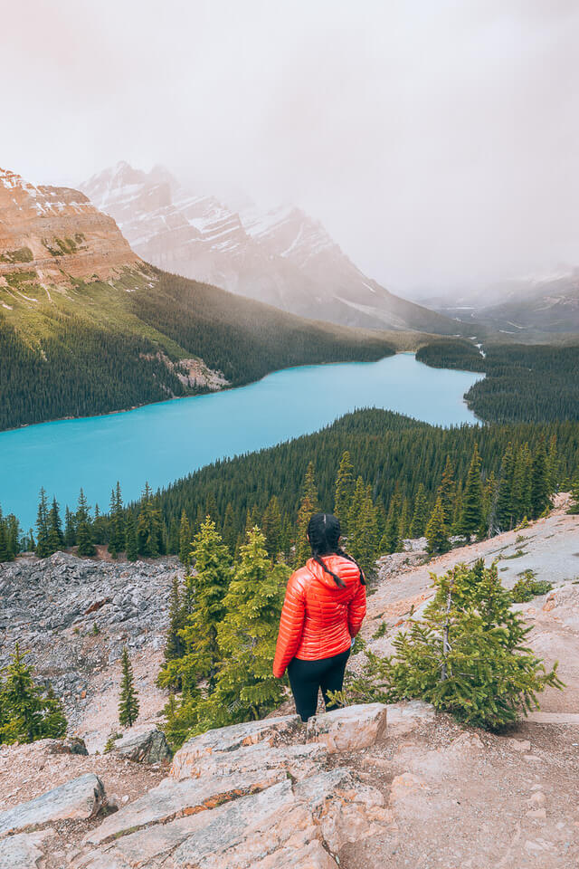
1. Peyto Lake Hike
Peyto Lake Hike Quick Facts:
Difficulty: Easy
Time: 0.5 Hour Round Trip
Elevation Gain: ~260 feet total elevation gain
Distance: ~1.6 miles round trip
Challenges: This trail can get extremely crowded. Going early is your best bet to beat the crowds.
Peyto Lake Lookout Trail is the most popular trail on the list. If you want to beat the crowds, I suggest going early. Sadly, we arrived in the middle of the day, so it was difficult to enjoy the beautiful views of Peyto Lake much less taking pictures.
The trail starts at the Bow Summit Lookout parking lot. The paved trail is well maintained and has several informational boards along the way. The path takes you through the trees on an upward slope until you get to a boardwalk. Once you are on the lookout, you can battle the crowds and take all the pictures you need.
Pro Tip: If the only time you can experience this is with the crowds, then there is an alternative on avoiding them. Continue on the paved trail and eventually, you will see a gravel path on the right. Follow that path for 0.5 km, and you will have an entirely new view without the massive crowds.
2. Chephren Lake Hike

Chephren Lake Quick Facts:
Difficulty: Moderate
Time: 3 Hour Return
Elevation Gain: ~260 feet total elevation gain
Distance: ~2.2 miles one way
Challenges: This trail is extremely muddy. Bring good hiking boots.
If you are looking for a stunning lake with surrounding mountain views but no crowds then this hike is for you! This trail starts out at the Waterfowl Lakes Campground. When you enter the parking lot, hang left, and there should be plenty of parking. The beginning of the trail takes you around the outer edge of Waterfowl Lakes Campground. Eventually, you will hear the rushing water of Mistaya River running along the side of the campground. Keep an eye out for a bridge and stop to take pictures on the bridge.
Once you have crossed the bridge, get ready for an uphill climb. This section is the most challenging area of the trail. The trail flattens out and takes you through a muddy passageway surrounded by trees. A while later you hit a junction (at about 0.8 miles), and you have to choose between visiting one of the two lakes. Chephren Lake or Cirque Lake.
Chephren Lake is the bigger lake of the two, more popular, and the trail is easier to complete. However, if you have the time to spare, you can visit both lakes which is about 8 miles round trip.
After turning right towards Chephren Lake, the trail at this point is pretty flat and straight. The trail is tranquil. The wind pushing against the tall trees causes the trees to speak to you as you hike through the forest. It is a calming yet off-putting experience. The primary challenge it to get through the trail without getting your socks wet! This area is muddy to the extreme! So make sure to bring proper shoes, or you will be struggling.
Eventually, you will run into the turquoise, blue lake, Chephren Lake. The best part of the trail is that there are no crowds. So more than likely, you will get this lake all to yourself. After taking all the pictures, you need turn back around and hike back to your car the same way.
GRAB MY [FREE] OUTDOOR BACKPACKER STARTER KIT:
I created the Ultimate Outdoor Backpacker Starter Kit for you (and it's FREE)! This starter kit is filled with 14 pages of my best hiking and backpacking tips to help you learn what it takes to become a safe, confident, and self-sufficient outdoor backpacker!
3. Parker Ridge Hike

Parker Ridge Trail Quick Facts:
Difficulty: Difficult
Time: 2.5 Hour Round Trip
Elevation Gain: ~820 feet total elevation gain
Distance: ~1.7 miles one way
Challenges: Finding a parking spot can be difficult.
Then Parker Ridge trail surprised me the most. I didn't read much about the trail before attempting it, so I wasn't sure what to expect. It is one of the best end views of the Icefields Parkway.
Parking can be a little hectic since the parking lot is small and the trail is popular. Per usual, arrive early to ensure you get a spot. Once you find a parking spot, head on up the mountain!
The trail leads you up the moderately steep sloped, switchbacks. Most of the hike is not covered by trees so bring sunscreen and of course, take in the views. The initial hike up to Parker Ridge has views of one side of the mountain which needless to say is pretty spectacular. The view includes an entire valley with a river flowing through it along with the Icefield Parkway. If you have never read anything on Parker Ridge before you might think that the summit will be a better view of Icefields Parkway, but you would be wrong.
Once you are at the summit, the trail will take you on the other side of the mountain, out of sight of the Icefields Parkway. In comes a new view of Saskatchewan Glacier and the surrounding mountains. Parker Ridge trail becomes a trail along the ridge of the mountain and flattens out. Even on a crowded day, there is enough room for everyone to digest their surroundings. The views are indeed out of this world. Many people bring their lunch up and enjoy a meal with a view. Once you are done soaking in the landscape, you will head back down the same way you came.
4. Wilcox Pass Hike
Wilcox Pass Quick Facts:
Difficulty: Difficult
Time: 3 to 3.5 Hour Round Trip
Elevation Gain: ~1,100 feet Elevation Gain
Distance: ~2.5 miles one way
Challenges: Finding a parking spot can be difficult.
My favorite hike in the Canadian Rockies, Wilcox Pass, is an absolute must on the Icefields Parkway. The views are outstanding, and it is one of the best spots to run into Bighorn Sheep (which we luckily did).
Parking can be a challenge if you go in the late morning. Once more, the earlier you arrive, the better. Parking is located at Wilcox Creek Campground entrance. The first part of the trail is set on an incline and surrounded by foliage. The obstruction of trees is rare on the trail and is only at the beginning. If you are patient and continue, the views will be worth it (less then a mile).
Eventually, the trail takes you above the treeline, and you have the first glimpse of the glorious views of Mount Athabasca. The continuously improving views are what makes the trail so incredible. The ever-changing landscape and viewpoints are just jaw-dropping, and you fall in love with it again and again. It is difficult not to stop every five minutes to take a picture.
The next area that catches everyone's eye is the red chair area. The red chair is an iconic symbol in the Candian Rockies. Jasper has 6 "red chair" areas scattered throughout the park, and the National Park encourages you to find them. Some visitors tend to turn around at this point, but I highly encourage everyone to continue the hike, especially if you want a chance to see the Bighorn Sheep.
After taking a picture on the chair, make your way up on a steep climb next to a ravine. After this section, the trail starts to flatten out. This is actually one of my favorite spots and the best area to spot bighorn sheep. The lush, green grass, the views of the outstanding mountains, and the sheep hanging lazily around really gives you such joy and happiness.
The trail will eventually take a sharp left. This is when the trail becomes difficult, with it taking you up and down some steep steps of limestone. This area can get pretty windy and cold so don't forget a jacket. If you are visiting in late spring or early fall, I suggest bringing traction cleats for snow because you might run into some on the hills. After scrambling up and down, you will get to the summit of Wilcox Pass (9,461 feet) with a grandiose 180-degree view of mountains and glaciers. Lucky for you, the views will be there once again for you to experience on your way back down.
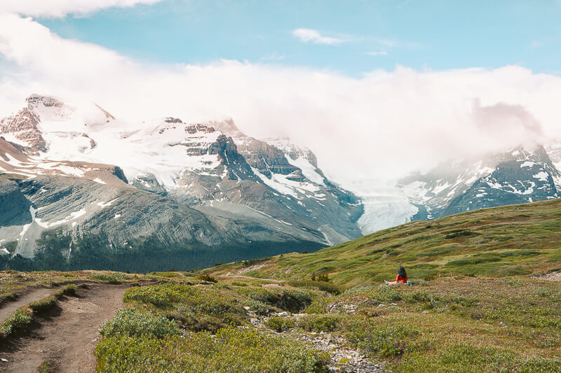
5. Athabasca Glacier Hike

Athabasca Trail Quick Facts:
Difficulty: Easy
Time: Less than an hour
Elevation Gain: ~200 feet total gain
Distance: ~1 miles round trip
Challenges: You can't hike on the actual Athabasca glacier
The Athabasca trail is the easiest hike listed in this post. It is also a trail many people skip out on because they have another option, the opportunity to walk ON the Athabasca Glacier. The Discovery Centre is located close to the Athabasca Glacier. The Discovery Centre includes the area in which you can buy tickets to walk on the Glacier. While expensive, walking on the glacier is a once in a lifetime opportunity, making it a common activity on the Icefields Parkway.
If you don't want to spend the money to walk on the Glacier, then hiking up to see a better view of the Athabasca is a cost-effective option. The trail is relatively easy (still an incline) and the views of the Athabasca are phenomenal. Throughout the trail and even near the Discovery Icefield Centre, markers are placed designating the historical lengths of the glacier at various times. The markers illustrate how large the glacier once was. The glacier's receding length over the past 150 years is truly saddening.
Throughout the hike, there are many warning signs about walking on the glacier without a guide. It is extremely dangerous without an expert so do not attempt to walk on the glacier. If a person falls into the cracks of the glacier, it is hard to rescue the person so best not to risk it. If you are with children, please keep a close eye on the kiddos as they are typically the ones who are the most unfortunate.
Grab My Day Hiking Packing Checklist!
The Icefields Parkway is filled with so many mighty mountains and glacial lakes that you can't help but fall in love with its surrounding natural beauty. I hope you enjoyed these five best Icefields Parkway hikes. I highly recommend reserving two full days along the Icefields Parkway to immerse yourself in the wild, beautiful area. The Icefields Parkway is one of the best road trips in the world so don't cut it short!

We hope you enjoyed this guest post from Michelle that details 5 of the best Icefield Parkway hikes. I can’t wait to do more traveling with Michael up to Canada, and I’m definitely adding Icefields Parkway to my list of must visit places. Hopefully we will get to go in the near future!
If you’re looking for more hiking adventure lists? Check out some of my other hiking guides:
Also, be sure to check out these essential hiking resources!
Cheers,
Allison - She Dreams of Alpine


Related Posts:


The 13 Best Great Basin National Park Hikes | Hiking in Great Basin National Park might fly under the radar compared to other more famous national parks, but that means you can find solitude and escape the crowds while exploring the ruggedly beautiful landscape. Hiking Great Basin National Park provides a variety of options to challenge yourself to summit a peak or simply go for a stroll among ancient trees. This park is a hidden gem, and hiking is one of the best ways to explore it! | shedreamsofalpine.com